Canada vs US Size: Which Country Is Actually Bigger?
Introduction
Ask most people which is bigger — Canada or the United States — and a surprising number will hesitate or get it wrong. The size of Canada vs US is one of the most commonly misunderstood geographic comparisons in the world, largely because maps have historically distorted the true size of northern countries. The US looms so large in global culture, politics, and media that people often assume it must be the bigger country too.
It isn’t.
Canada is, in fact, the second largest country on Earth — and it is measurably larger than the United States in total area. But the comparison is more nuanced than a single number, because how you measure “size” — total area, land area only, freshwater included or excluded — changes the result. This guide breaks it all down completely.
Size of Canada vs US: The Core Numbers
| Measurement | Canada 🇨🇦 | United States 🇺🇸 |
|---|---|---|
| Total Area (land + water) | 9,984,670 km² | 9,833,517 km² |
| Land Area Only | 9,093,507 km² | 9,147,593 km² |
| Freshwater Area | 891,163 km² | 685,924 km² |
| World Ranking (total area) | 2nd largest | 3rd or 4th largest |
| World Ranking (land only) | 4th | 3rd |
| North–South Span | ~4,600 km (2,860 miles) | ~2,500 km (1,550 miles) |
| East–West Span | ~5,500 km (3,400 miles) | ~4,500 km (2,800 miles) |
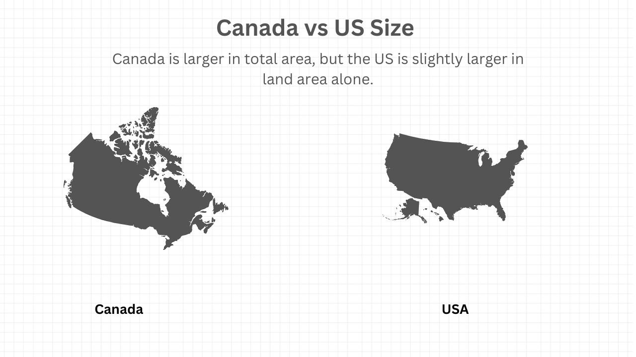
Here is the nuance that explains everything: Canada is larger in total area, but the US is slightly larger in land area alone.
Canada’s total area of 9,984,670 km² edges out the US total of 9,833,517 km² — making Canada larger by approximately 151,000 km² when water bodies are included. However, Canada contains an enormous amount of freshwater — lakes, rivers, and inland seas — and when only dry land is counted, the US comes out slightly ahead at 9,147,593 km² vs Canada’s 9,093,507 km².
The bottom line: Canada wins on total area. The US wins on land area alone. The difference either way is less than 2%. These two countries are remarkably close in overall size — separated by a margin of less than one percent of their total area.
Why Canada Looks Smaller on Maps Than It Really Is
This is one of the most fascinating aspects of the Canada vs US size comparison — and one of the biggest geographic misconceptions in popular culture.
Most world maps use the Mercator projection — a mapping technique developed in 1569 by Flemish cartographer Gerardus Mercator. The Mercator projection distorts the size of land masses the further they are from the equator. Countries near the poles appear far larger than they actually are in reality — but Canada, despite being near the north pole, is still enormous even on accurate projections.
The more common problem is cultural. The United States dominates global media, culture, and geopolitics to such a degree that people unconsciously assume it must also be the physically dominant country. Maps in American textbooks have historically been US-centric, sometimes showing Canada as a comparatively thin strip of land above the border. In reality, Canada stretches further north, further east, and is an enormously vast landmass that dwarfs most countries on Earth.
To put Canada’s true size in perspective:
- Canada is larger than the entire European Union (including the UK)
- Canada is larger than China (9,596,960 km²) in total area
- Canada is larger than Brazil (8,515,767 km²)
- Canada is 26 times larger than Germany
- Canada is 40 times larger than the United Kingdom
- Canada is 3 times larger than India
Detailed Land Area Breakdown
Canada by Province and Territory
Canada is divided into 10 provinces and 3 territories — and several of these individual subdivisions are themselves enormous by world standards.
| Province / Territory | Area (km²) | Comparison |
|---|---|---|
| Nunavut | 2,093,190 | Larger than Mexico |
| Quebec | 1,542,056 | Larger than Alaska |
| Northwest Territories | 1,346,106 | Larger than Colombia |
| British Columbia | 944,735 | Larger than France and Germany combined |
| Ontario | 1,076,395 | Larger than Texas and California combined |
| Alberta | 661,848 | Larger than Ukraine |
| Saskatchewan | 651,036 | Larger than Pakistan’s Punjab province |
| Manitoba | 647,797 | Larger than Spain |
| Yukon | 482,443 | Larger than Sweden |
| Newfoundland & Labrador | 405,212 | Larger than Japan |
The sheer scale of Canada’s individual provinces is staggering. Nunavut alone — Canada’s largest and newest territory — is bigger than the entire country of Mexico. Quebec is larger than Alaska. Ontario is larger than Texas and California combined. These are not small subdivisions of a large country; they are continent-sized regions in their own right.
United States by Region
The United States is divided into 50 states — ranging from the massive to the tiny.
| State | Area (km²) | Comparison |
|---|---|---|
| Alaska | 1,723,337 | Larger than Quebec |
| Texas | 695,662 | Larger than Alberta |
| California | 423,970 | Larger than Newfoundland & Labrador |
| Montana | 380,831 | Larger than Germany |
| New Mexico | 314,917 | Larger than Poland |
| Rhode Island | 4,001 | Smaller than Prince Edward Island |
Alaska — by far the largest US state — would rank as the 3rd largest Canadian province/territory if it were Canadian. Texas, often cited as an example of American bigness, is comfortably smaller than Ontario and Quebec.
Coastline: Canada Wins by an Enormous Margin
When it comes to coastline length, the comparison isn’t even close — Canada has the longest coastline of any country on Earth, by a very wide margin.
| Country | Coastline Length |
|---|---|
| 🇨🇦 Canada | 202,080 km (125,567 miles) |
| 🇺🇸 United States | 19,924 km (12,383 miles) |
| Difference | Canada has 10× more coastline |
Canada’s extraordinary coastline — winding through thousands of Arctic islands, bays, fjords, and inlets — is so long that it wraps around more than five times the circumference of the Earth. The US coastline, while impressive, is dwarfed by comparison. Canada’s coastline touches three oceans: the Atlantic, Pacific, and Arctic — the only country in the Western Hemisphere to border all three.
Freshwater: Canada’s Most Remarkable Size Statistic
Canada’s freshwater holdings are perhaps its most staggering geographic feature — and they contribute enormously to its total area advantage over the US.
| Freshwater Stat | Canada 🇨🇦 | United States 🇺🇸 |
|---|---|---|
| Total Freshwater Area | 891,163 km² | 685,924 km² |
| Share of World’s Freshwater | ~20% | ~8% |
| Number of Lakes | ~2 million | ~250,000 |
| Largest Lake System | Great Lakes (shared with US) | Great Lakes (shared with Canada) |
Canada holds approximately 20% of the world’s total surface freshwater — the largest freshwater reserve of any country on Earth. The Great Lakes alone — shared between Canada and the United States — contain roughly 21% of the world’s surface freshwater by volume. Canada also contains Great Bear Lake, Great Slave Lake, Lake Winnipeg, and thousands of smaller lakes scattered across the boreal shield.
This extraordinary freshwater wealth is a defining feature of Canada’s geographic character — and a resource of immense long-term strategic value as global freshwater becomes increasingly scarce.
Population Density: Where the Real Difference Lies
While Canada and the US are nearly equal in physical size, their populations tell a completely different story — and this contrast is perhaps the most surprising fact in the entire comparison.
| Stat | Canada 🇨🇦 | United States 🇺🇸 |
|---|---|---|
| Population (2025 est.) | ~41 million | ~340 million |
| Population Density | ~4.2 people/km² | ~34.6 people/km² |
| Most Populated City | Toronto (~6.3 million metro) | New York (~20 million metro) |
| % living within 160 km of US border | ~90% | N/A |
Canada has roughly 8 times fewer people than the United States, spread across a country of nearly equal size. This gives Canada one of the lowest population densities of any country on Earth — approximately 4.2 people per square kilometer, compared to the US’s 34.6.
Perhaps the most striking demographic fact about Canada’s geography: approximately 90% of all Canadians live within 160 km (100 miles) of the US border. The vast majority of Canada’s enormous landmass — particularly the north — is essentially uninhabited. The entire northern half of Canada, comprising millions of square kilometers of boreal forest, tundra, and Arctic territory, is home to only a tiny fraction of the population.
Climate & Geographic Zones: Size Creates Diversity
Canada’s enormous size — spanning nearly 5,500 km from east to west and 4,600 km from south to north — means it encompasses a staggering range of climate zones and geographic environments.
| Zone | Location in Canada | US Equivalent |
|---|---|---|
| Arctic Tundra | Nunavut, northern territories | Northern Alaska only |
| Boreal Forest (Taiga) | Across most of northern Canada | Small sections of northern Minnesota/Maine |
| Temperate Rainforest | British Columbia coast | Pacific Northwest (Oregon/Washington) |
| Prairie/Grassland | Alberta, Saskatchewan, Manitoba | Great Plains states |
| Mixed Forest | Ontario, Quebec, Maritime provinces | Northeast US states |
| Arctic Archipelago | Canadian Arctic Islands | No US equivalent |
Canada’s Arctic Archipelago — a vast collection of islands in the far north — has no equivalent in the continental United States. This region alone adds hundreds of thousands of square kilometers to Canada’s total area and gives it sovereignty over some of the most remote and climatically extreme territory on Earth.
The US, by contrast, has greater climate diversity in its southern regions — deserts, tropical zones (Hawaii, Florida), and subtropical environments that Canada entirely lacks. What Canada has in raw size and northern territory, the US balances with greater southern diversity.
Border: The World’s Longest International Border
The border between Canada and the United States is the longest international border in the world — a fact that is itself a testament to the enormous size of both countries.
| Border Stat | Measurement |
|---|---|
| Total border length | 8,891 km (5,525 miles) |
| Continental US–Canada border | 6,416 km (3,987 miles) |
| Alaska–Canada border | 2,475 km (1,538 miles) |
| Number of border crossings | 119 official crossings |
| Nickname | “The World’s Longest Undefended Border” |
This border — largely following the 49th parallel across the western portion and a complex series of rivers, lakes, and survey lines in the east — is famous for being almost entirely unfortified. The two countries share the longest friendly border of any two nations on Earth, a reflection of their deep political, economic, and cultural ties.
Size Comparison: Canada vs US States
One of the most intuitive ways to appreciate the size of Canada vs the US is to compare Canadian provinces directly to US states:
| Canadian Province/Territory | Comparable US State(s) |
|---|---|
| Nunavut (2,093,190 km²) | Alaska + Texas + California combined |
| Quebec (1,542,056 km²) | Alaska (1,723,337 km²) — slightly smaller |
| Ontario (1,076,395 km²) | Texas + California combined |
| British Columbia (944,735 km²) | Texas + New Mexico |
| Alberta (661,848 km²) | Texas |
| Saskatchewan (651,036 km²) | Texas (slightly smaller) |
| Manitoba (647,797 km²) | Texas (slightly smaller) |
| Nova Scotia (55,284 km²) | West Virginia |
| Prince Edward Island (5,660 km²) | Delaware |
The pattern is clear — Canada’s largest provinces are themselves continent-sized territories that match or exceed the largest US states. Even mid-sized Canadian provinces like Manitoba and Saskatchewan are comparable in area to Texas — the state Americans most often cite as an example of vast size.
Fun Size Facts: Canada vs US
🍁 Canada is so wide that it spans 6 time zones — the same as the continental US (which also spans 4 in the lower 48, plus Alaska and Hawaii).
🗺️ If you drove across Canada from St. John’s, Newfoundland to Victoria, British Columbia, you’d travel approximately 7,604 km (4,726 miles) — further than driving from New York to Los Angeles and back again.
🧊 Canada’s Baffin Island (507,451 km²) is the 5th largest island in the world — larger than Spain — and is largely uninhabited. The US has no island even close to this size.
🌊 Canada’s Hudson Bay is so large — 1,230,000 km² — that it is considered an inland sea. It is larger than the entire country of Egypt.
🏔️ Canada’s highest peak is Mount Logan in the Yukon at 5,959 m — the second highest peak in North America after Denali in Alaska, and the largest mountain by base area in the world.
🌲 Canada contains approximately 9% of the world’s forests — more forested area than any other country except Russia. The Canadian boreal forest alone is larger than the Amazon rainforest.
🐻 Canada’s landmass is so vast that it provides habitat for approximately 200,000 polar bears, 500,000 grizzly bears, and millions of caribou — wildlife populations on a scale impossible in the more densely populated United States.
Head-to-Head Size Summary
| Category | Canada 🇨🇦 | United States 🇺🇸 | Winner |
|---|---|---|---|
| Total area (land + water) | 9,984,670 km² | 9,833,517 km² | 🇨🇦 Canada |
| Land area only | 9,093,507 km² | 9,147,593 km² | 🇺🇸 USA |
| Coastline length | 202,080 km | 19,924 km | 🇨🇦 Canada (by 10×) |
| Freshwater area | 891,163 km² | 685,924 km² | 🇨🇦 Canada |
| Number of lakes | ~2 million | ~250,000 | 🇨🇦 Canada |
| North–South span | ~4,600 km | ~2,500 km | 🇨🇦 Canada |
| East–West span | ~5,500 km | ~4,500 km | 🇨🇦 Canada |
| Number of time zones | 6 | 6 (incl. AK & HI) | Tie |
| World size ranking | 2nd | 3rd–4th | 🇨🇦 Canada |
| Population | ~41 million | ~340 million | 🇺🇸 USA |
| Population density | 4.2/km² | 34.6/km² | — |
Key Takeaways: Size of Canada vs US
- Canada is the 2nd largest country in the world by total area; the US is 3rd or 4th
- Canada wins on total area (9.98 million km² vs 9.83 million km²) when water is included
- The US wins on land-only area by a slim margin (~54,000 km²)
- Canada has 10 times more coastline than the United States
- Canada holds approximately 20% of the world’s surface freshwater
- Despite similar size, Canada has 8× fewer people than the US — one of the lowest population densities on Earth
- ~90% of Canadians live within 160 km of the US border — the vast northern interior is largely empty
- The US–Canada border is the longest international border in the world at 8,891 km
Conclusion
The size of Canada vs US comparison delivers a clear but nuanced verdict: Canada is the larger country by total area, the US is marginally larger by land area alone, and the difference between the two is remarkably small — less than 2% either way. These are the two largest countries in the Western Hemisphere and two of the largest on Earth, separated by the world’s longest friendly border and connected by the world’s largest bilateral trading relationship.
What makes the comparison truly fascinating is not the raw numbers but what those numbers mean — Canada’s vast size is dominated by uninhabited wilderness, freshwater, and Arctic territory, while the US packs a far larger population into a similar footprint. Canada is bigger on the map; the United States is bigger in almost every human measure. Together, they represent one of the most complementary geographic partnerships in the world.